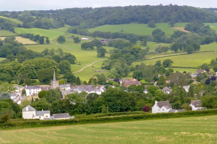
Starting and finishing in one of the oldest settlements in Devon this walk takes you on a journey through ancient fields, woods, wild areas and historic green lanes in the hills and valleys around Sidbury, Harcombe and Sweetcombe.
Linking woods and copses then emerging into fields with sudden unexpected vistas of rural East Devon this route gives a wonderful sense of the past and the hidden beauty of this area.
Additional Information
Full of wildlife
The broadleaved woods and copses around Sidbury are a rich habitat for a wide variety of wildlife. Look out for woodland birds including nuthatches, woodpeckers and long tailed tits and for buzzards soaring overhead when you emerge into open fields. Ferns grow in abundance in the damper areas and you may be lucky enough to catch a glimpse of a roe deer bounding away through the undergrowth.
Directions
1 - 5. From the public car park in Sidbury, turn right and then right again and walk out to the main road.
Turn right along the road making best use of the pavements to pass the Red Lion Inn and the church.
2. Turn left and join the East Devon Way down Bridge Street. Cross the mill race and then the River Sid and, ignoring the first turning to the right, walk on up to the T-junction.
3. Turn right and then, just after the farmyard, turn left through a kissing gate and up a flight of steps into a field. Bear left and head for a gate in the top left corner of the field.
4. Go through the gate, cross a small stream and turn left to follow the hedge on your left up to a stile in the top left corner of the field.
5. Cross the stile and head straight up the field and over another stile and plank bridge into the woods.
6 - 10. Continue straight up the very steep rough footpath until you reach the level hilltop. The path bears right and then left to a junction of paths.
7. Turn left (north easterly) and follow the bridleway along the track following the watershed between the Sweetcombe, Roncombe and Sid Valleys until you come to a minor road at Hatway Hill.
8. Turn left down the hill for approx 440 yards/402 metres and take the footpath on the right opposite Hatway Cottage.
9. Follow the hedge on your left and go through a gate into some woodland. Continue to follow the East Devon Way through the woods and out over a stile into a field.
10. Go straight across the field and through a kissing gate into another woodland. Follow the footpath through the woods. The path is on a springline and can be wet and muddy in places. There are two boardwalks over the wettest sections.
11 - 15. Ignore the footpath on the left and continue to a gate.
Go through the gate and follow the path along the edge of the wood. Go straight across a farm track and head on along the top of a field with a bank on your right to a 2 in 1 gate into Mincombe Wood.
12. Go through the gate and continue along the path through Mincombe Wood to a wooden gate. This path can be rough, wet and stony in places. Go through the gate and follow the fenced footpath as it bears right to a stile out onto a minor road.
13. Go straight across the road onto a broad track leaving the East Devon Way. Follow the track towards a farm.
14. Fork right off the track just before the farm and follow the fence line and elevated path to the right of the farm.
15. After passing the farm go through a metal gate and continue along the track close to the edge of the wood on your left. After approx 175 yards/160 metres look out for a gate on the left into the woods.
16 - 20. Go through the gate and follow the bridleway downhill
to the right through the woods, eventually passing out through a gate into a field. This path can be wet, rough and stony in places.
17. Continue to follow the bridleway along the line of a former hedge bank on your right. Go through a gate and over a footbridge to a path junction. Turn left onto a steep track down along the edge of the woods.
18. After 44 yards/40 metres take the bridleway that branches off to the right through the conifer wood. At the first junction of paths turn right and at the next junction turn left to follow the bridleway through the conifer wood for 547 yards/500 metres to a gate out into a field.
19. Go through the gate and follow the field boundary on your left to another gate close to Lower Sweetcombe Farmhouse.
20. Go through the gate and turn right to cross the concrete farm drive and head uphill along a grassy track with a hedge on your right. Where the bridleway divides above the house, turn left to a gate.
21 - 25. Go through the gate and follow the bridleway along a broad track with a hedge on your left.
Do glance up to your right along here and look out for the top of a chimney sticking up above the hill. The rest of the house is hidden by the slope.
22. Go through a second gate and continue straight on along a grassy track towards some woods. Where the track divides before the next gate bear right uphill to skirt alongside the copse on your left to a metal field gate.
23. Go through the gate and follow the bridleway down slightly left alongside a wire fence on the left. Continue to another gate. This stretch can be muddy in winter.
24. Go through the gate and head straight on through the trees staying parallel with the fence on your left to another gate.
25. Go through the gate and head straight on through a wild area staying parallel with the bank on your left and eventually climbing uphill to another gate.
26 - 30. Look out for the ancient beeches growing along the bank here.
Immediately after the gate turn left downhill and around to the right staying parallel with the fence on your left.
27. When you come to the end of the trees head straight across the field to another block of woodland and then turn left downhill alongside it to a metal gate.
28. Go through the gate and continue downhill following a wet stone track down through the edge of a woodland and around to the right.
29. Follow the bridleway along a green lane for approx 875 yards/800 metres ignoring all side turns until you come to a junction. It can be very wet and muddy in places in the winter.
30. Where the track divides keep right and after 22 yards/20 metres look for a footpath on you right. Climb over the stile into a field and follow the hedge on your left to the wood on Buckton Hill.
31 - 35. Climb over a second stile into the wood and follow the waymarked footpath that winds through the trees.
32. At the junction of paths keep left following the boundary on the right before bearing left up some rough steps and following the path more steeply uphill. The footpath eventually bears left alongside a hedge with a field on your left to reach a kissing gate and another junction of paths.
33. Go through the kissing gate and turn right along a track for a short distance to another junction of paths where you were earlier. Turn left along a footpath initially on the level following the path around to the right and then left to descend steeply through the wood.
34. Leave the wood via a narrow footbridge and stile and head straight down the field to another stile. Cross the stile and follow the hedge on your right crossing a ditch to go through a gate on the right as the hedge starts to bear around to the left.
35. Go through the gate and bear left heading for the left hand end of the farm buildings where the path bears right down to a flight of steps and a kissing gate.
36 - 38. Go through the gate
and turn right along the road and then take the first left opposite the farm and follow the road downhill towards Sidbury.
37.Go straight on over the bridge and up to the main road.
38.Turn right and, making best use of the pavements, retrace your steps past the Red Lion Inn and the church, turning left and then left again to reach the village car park.
This route was originally developed by James Baldwin and checked by Ted Swan. It was reviewed and updated in 2025.